Phase 1In preparation
Forest-edge community compacts
Consultation with communities bordering the Oban and Okwangwo divisions on protection and benefit sharing.
The People's Paradise
Cross River holds the largest surviving block of tropical rainforest in Nigeria and anchors the region's biodiversity and eco-tourism case. Calabar was a major historic port and remains a cultural centre, while the northern uplands around Obudu support agriculture and highland tourism.
State at a glance
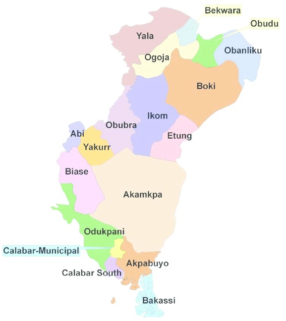
This reference map shows the state's local government areas. Select any fact below for a focused view of the state profile.
Capital
Calabar
Created
27 May 1967
Origin
Created as South-Eastern State; renamed Cross River in 1976
Local government areas
18
Land area
20,156 km²
Population (2006 census)
2,892,988
Peoples
Efik · Ejagham · Bekwarra · Yakurr · Boki · Ogoja peoples
Project updates
Consultation with communities bordering the Oban and Okwangwo divisions on protection and benefit sharing.
Scoping of estuary waste capture and shoreline restoration around the Calabar channel.
Preparation of forest carbon documentation to attract long-term conservation funding.
Updates describe the planned campaign pipeline in this state. Delivery figures are published only after field verification.
Restoration initiatives
Paid local ranger roles protecting rainforest blocks and Cross River gorilla habitat.
Guiding, hospitality and craft enterprise around Obudu and the national park.
Riverbank replanting to safeguard downstream water quality for the wider Delta.
Rainforest protection and community forest-guard programmes
Eco-tourism and conservation livelihoods for forest-edge communities
Catchment protection for downstream water quality
Ambassadors in Cross River
Mobilise your community, report field conditions and help deliver the Cross River programme pipeline.
Become an Cross River AmbassadorDonors and funders
Back a named priority here through grants, corporate support or in-kind technical expertise. No payment is collected online — every enquiry starts with a conversation.
Support Cross River projectsRegional operations map
Switch layers to explore state profiles, programme locations, pipeline indicators and collaborators.
Interactive Niger Delta campaign map. Choose a map layer, then activate its markers to reveal details. State markers support Arrow keys, Home and End.

Locations indicate programme focus or regional reach, not precise worksites or office addresses. Map supplied as a geographic reference.
The People's Paradise
Capital Calabar · 18 LGAs · 20,156 km²
Phase 1
In preparationConsultation with communities bordering the Oban and Okwangwo divisions on protection and benefit sharing.
Phase 1
PlannedScoping of estuary waste capture and shoreline restoration around the Calabar channel.
Regional programme: Safe Water Access · Needs assessment
Sources: Nigeria's 2006 national population census, official state creation records, the 2011 UNEP Environmental Assessment of Ogoniland, and state material reproduced from Niger Delta Organisation SA. Figures are historical official records; current estimates are higher, and area totals may vary by public source.