Phase 1In preparation
Ilaje shoreline risk map
Community-led mapping of erosion, ocean surge and threatened public infrastructure along the coastal belt.
Sunshine State
Ondo links the forest and cocoa belt of south-western Nigeria to the Atlantic coast. Its Ilaje and Ese-Odo communities form the state's oil-producing Niger Delta zone, where creeks, mangroves, fisheries and coastal settlements face mounting environmental pressure.
State at a glance
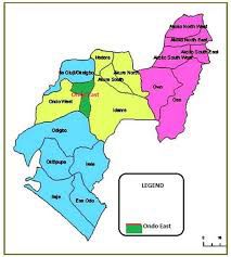
This reference map shows the state's local government areas. Select any fact below for a focused view of the state profile.
Capital
Akure
Created
3 February 1976
Origin
Created from the former Western State
Local government areas
18
Land area
Approx. 14,789 km²
Population (2006 census)
3,441,024
Peoples
Yoruba groups including Akoko, Akure, Ikale, Ilaje, Ondo and Owo, with Apoi and Ijaw communities
Project updates
Community-led mapping of erosion, ocean surge and threatened public infrastructure along the coastal belt.
Sampling plan for drinking-water sources and fishing creeks in Ilaje and Ese-Odo.
Identify sheltered estuarine sites for community nurseries and monitored replanting.
Updates describe the planned campaign pipeline in this state. Delivery figures are published only after field verification.
Restoration initiatives
Combine mangroves, dune vegetation and appropriate protection works for exposed settlements.
Raised, maintainable treatment points serving hard-to-reach coastal communities.
Habitat recovery and livelihood support developed with fishing cooperatives.
Coastal protection and managed resilience for Ilaje settlements
Mangrove and fisheries restoration
Spill readiness and clean water for riverine communities
Ambassadors in Ondo
Mobilise your community, report field conditions and help deliver the Ondo programme pipeline.
Become an Ondo AmbassadorDonors and funders
Back a named priority here through grants, corporate support or in-kind technical expertise. No payment is collected online — every enquiry starts with a conversation.
Support Ondo projectsRegional operations map
Switch layers to explore state profiles, programme locations, pipeline indicators and collaborators.
Interactive Niger Delta campaign map. Choose a map layer, then activate its markers to reveal details. State markers support Arrow keys, Home and End.

Locations indicate programme focus or regional reach, not precise worksites or office addresses. Map supplied as a geographic reference.
Sunshine State
Capital Akure · 18 LGAs · Approx. 14,789 km²
Phase 1
In preparationCommunity-led mapping of erosion, ocean surge and threatened public infrastructure along the coastal belt.
Phase 1
PlannedSampling plan for drinking-water sources and fishing creeks in Ilaje and Ese-Odo.
Sources: Nigeria's 2006 national population census, official state creation records, the 2011 UNEP Environmental Assessment of Ogoniland, and state material reproduced from Niger Delta Organisation SA. Figures are historical official records; current estimates are higher, and area totals may vary by public source.