Phase 1In preparation
Gully erosion mapping in Esan and Etsako
Community-verified survey of active gully heads around Auchi and Ekpoma to rank sites by risk to homes, roads and farmland.
Heartbeat of the Nation
Edo is the cultural anchor of the region, home to the historic Benin Kingdom whose bronzes are held in museums worldwide and are the subject of ongoing restitution. The state combines oil and gas activity in the south with rubber, timber, cocoa and quarrying in the uplands.
State at a glance
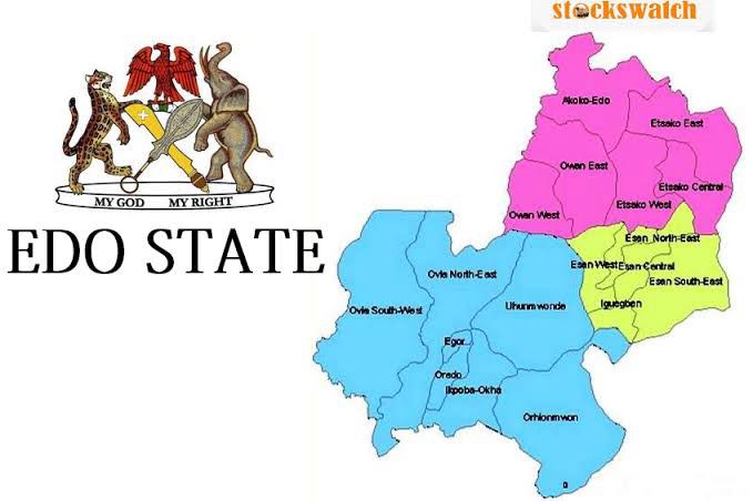
This reference map shows the state's local government areas. Select any fact below for a focused view of the state profile.
Capital
Benin City
Created
27 August 1991
Origin
Carved out of the former Bendel State
Local government areas
18
Land area
17,802 km²
Population (2006 census)
3,233,366
Peoples
Edo (Bini) · Esan · Afemai (Etsako, Owan) · Akoko-Edo · Ijaw
Project updates
Community-verified survey of active gully heads around Auchi and Ekpoma to rank sites by risk to homes, roads and farmland.
Assessment of blocked storm channels and informal dumpsites ahead of a recycling enterprise pilot.
Agreement framework with forest-edge communities around Okomu and Gilli-Gilli for protected replanting blocks.
Updates describe the planned campaign pipeline in this state. Delivery figures are published only after field verification.
Restoration initiatives
Train local crews in check dams, vegetative bunds and drainage works at priority gully sites.
Link Benin Kingdom heritage sites to clean-city and urban greening work.
Support replanting of degraded rubber and cocoa plots with mixed-species agroforestry.
Gully erosion control and slope stabilisation with affected communities
Forest reserve protection and replanting
Urban drainage, waste recovery and recycling enterprise in Benin City
Ambassadors in Edo
Mobilise your community, report field conditions and help deliver the Edo programme pipeline.
Become an Edo AmbassadorDonors and funders
Back a named priority here through grants, corporate support or in-kind technical expertise. No payment is collected online — every enquiry starts with a conversation.
Support Edo projectsRegional operations map
Switch layers to explore state profiles, programme locations, pipeline indicators and collaborators.
Interactive Niger Delta campaign map. Choose a map layer, then activate its markers to reveal details. State markers support Arrow keys, Home and End.

Locations indicate programme focus or regional reach, not precise worksites or office addresses. Map supplied as a geographic reference.
Heartbeat of the Nation
Capital Benin City · 18 LGAs · 17,802 km²
Phase 1
In preparationCommunity-verified survey of active gully heads around Auchi and Ekpoma to rank sites by risk to homes, roads and farmland.
Phase 1
PlannedAssessment of blocked storm channels and informal dumpsites ahead of a recycling enterprise pilot.
Regional programme: Women & Youth Green Skills · Partnership mobilisation
Sources: Nigeria's 2006 national population census, official state creation records, the 2011 UNEP Environmental Assessment of Ogoniland, and state material reproduced from Niger Delta Organisation SA. Figures are historical official records; current estimates are higher, and area totals may vary by public source.